
Satellite cloud images help you understand the weather: What does a "front" look like? What is an "upward cloud top"?
|
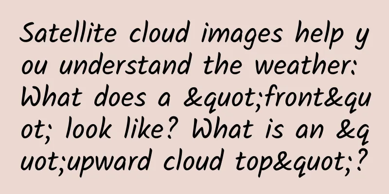
Front Does the term “front” look very professional? In fact, it is the interface or transition zone between two air masses with different physical properties such as temperature and humidity. In simple terms, it is the interface between cold and warm air masses. The intersection of the front and the ground is called the front line, or simply the front. The length of a front can generally range from several hundred kilometers to several thousand kilometers, and can extend more than ten kilometers in the vertical direction. According to the thermodynamic classification method, if a cold air mass pushes a warm air mass forward, it is called a cold front; otherwise, it is a warm front. If the cold and warm air masses are of equal strength, it is called a quasi-stationary front. If a cold front catches up with a warm front, an occluded front will form. Without further ado, maybe you will understand it by combining it with satellite cloud images! The arrow in the figure points to the cold front. What should I do if I see a cold front? In winter, the cold front is strong and brings cold waves; in summer, the cold wind is weak and brings thunderstorms. Attention! When a cold front passes through, the temperature difference between two places in the same province can reach more than ten degrees. Remember to add or remove clothes appropriately! Up to the top As a characteristic of severe storms, upthrust cloud tops are associated with updrafts that clearly penetrate the equilibrium altitude (i.e., the altitude of the broad thunderstorm cloud tops). In the visible light cloud images of Fengyun satellites, upthrust cloud tops appear as bright bulges, like "little bumps". Bright bulges above the cloud tops can be seen at locations A, B, and C in the picture. What should I do if I see the sky heading up to the top of the clouds? The appearance of upthrust cloud tops indicates the presence of strong updrafts in the area and a high likelihood of severe weather. Roller Cloud Also known as wave clouds, they are horizontal, tube-shaped clouds. Wave clouds are created when stable air is disturbed, causing the air to move along the disturbance, like waves in a pond. This disturbance is usually created when cold, dry air from a moving cold front collides with a relatively stable area of warm, moist air. If the stable layer of air is moist, clouds form on top as the air flows upward. When the air flows downward, the clouds evaporate. The alternating absence and presence of clouds is what creates the wave effect. (Photo/Text by Jia Xu and Xie Yifei) The arrow in the picture points to the roller cloud. This type of cloud system mainly occurs over the sea and may indicate that a squall line or thunderstorm is approaching. Once you see it, please return to a safe place in time to be on the safe side. |
<<: 167 flights a year! This professor's belief ignites countless people


Recommend
The efficacy and function of wolf grass
Wolfsbane is a medicinal herb frequently used in ...
A map tells you where to see the most beautiful volcanic lake in China
Loading long image... Source: National Geographic...
The efficacy and function of mountain orange leaves
Everyone is familiar with mountain citrus leaves....
Can eating wolfberry help you lose weight?
Wolfberry is a traditional Chinese medicine, a no...
Illustration | Is returning straw to the fields a good idea?
Crop straw It is the other half of agricultural p...
How did the "wings" of spacecraft come from? Read the aerospace story of solar cells in one article
People who are interested in aerospace are very f...
You bump into it and you say "ouch", it bumps into it and you say 130 billion
END Tadpole's original work, please indicate ...
This inconspicuous "little white flower" actually has its own festival
Other names: bellflower, grass bell, royal shadow...
Why does a car not start when it comes into contact with vanilla ice cream?
A true but somewhat absurd story: A Pontiac car u...
The efficacy and function of Rubus rubus
Speaking of red-haired Rubus, I believe many frie...
What is the medicinal value of the hawksbill turtle?
Speaking of hawksbill turtles, I believe that few...
Will eating persimmons on an empty stomach cause kidney stones? Will eating persimmons make anemia patients' condition worse? Pay attention to these 3 points and eat persimmons without worry →
gossip Autumn is a time for abundant harvests. Th...
The efficacy of Xianghe
Xianghe is a rhizome, which can be eaten as a sti...
The efficacy and function of red fungus
Traditional Chinese medicine has always been the ...
Can pregnant women eat steamed pear with Fritillaria?
Pregnant women should pay special attention to th...